

Panorama

Showing posts with label Vegetation/Topography. Show all posts
Showing posts with label Vegetation/Topography. Show all posts
Monday, December 10, 2012

Saturday, December 8, 2012
Wolf House and its Surrounding
 |
| Wolf House in daylight |
 |
| Wolf Residence at nightfall |
Although located beside a public park, Wolf House still possesses a fairly high level of privacy. It is surrounded by trees and high bushes. The house it is self is sided by aluminum panels.Flourishing trees create wonderful shades in summer which lower temperature in the house.
  |
| Privacy of the residence is well protected from the public park besides it |
 |
| The courtyard and back yard are well hidden even in winter |
 |
| The wall facing the neighbor is fully covered by aluminum siding |

 |
| Roxborough Driveway in front of Wolf House; the dwelling across is blocked by vegetation in summer |
 |
| Overlooking into the public park from major intersection, Wolf House is well hidden behind the trees |

Thursday, December 6, 2012
Toronto Ravines
Formed after the last ice age 12,000 years ago, Toronto's ravines were created through the soil erosion of small creeks and rivers. Today, notable rivers such as the Humber and Don river, run through some of these ravines and created Toronto's ravine system. It is a network of ravines that forms a urban forest-- a forest that resides in a city.
 |
| Don River |
During the spring and major storms, it is common for these ravines to overflow to the extent where every few decades, a massive flood occurs. In 1954, Hurricane Hazel brought down 5 inches of rain which also effected the soil that was already waterlogged beforehand. This led to serious damaged and fatalities.
 |
| Result of Hurricane Hazel in Toronto, 1954 |
In the post war era, there were developments that worked towards the repairing of the city and the ravines. It was noted that the soil of the ravines were too sandy, making it unsuitable for agriculture.
Rosedale, one of Toronto's notable ravine neighbourhood, is surrounded by smaller ravines that branch off from the west of the lower Don River. Near the Rosedale ravine lies the Don Valley Bricks Works. This facility used clay, shale and other natural materials that were deposited from the glacier and manufactured 43 million bricks after WWII. These bricks were used to build significant buildings in Toronto, such as Old City Hall and Massey Hall.
"It's a city of ravines ...Through these great sunken gardens you can traverse the city beneath the streets, look up to the floating neighbourhoods, houses built in the treetops" --Anne Michaels, Fugitive Pieces
Many predict that in a hundred years, Toronto will start relying on the resources provided from the ravines. The ravine system would help dense housing since it would be efficient to place these housing along the edges of the ravine. Originally, ravines were a source of fuel, food, water, but since the 1800's it has been polluted. Not to mention, ravines interrupted the street grid and was a breeding ground for pests.
Unfortunately, we have built over most of these ravines to the point where it's unrecognizable that a ravine ever existed there. We started to engineer our ravines which was also a sign of our belief of taming or civilizing nature. Today, however, we are starting to revive some of these ravines to create spaces for hikers, cyclists etcetera. In the near future, Toronto hopes to work more with ravines, especially in the Rosedale area where dense, terraced houses would erect.
Unfortunately, we have built over most of these ravines to the point where it's unrecognizable that a ravine ever existed there. We started to engineer our ravines which was also a sign of our belief of taming or civilizing nature. Today, however, we are starting to revive some of these ravines to create spaces for hikers, cyclists etcetera. In the near future, Toronto hopes to work more with ravines, especially in the Rosedale area where dense, terraced houses would erect.
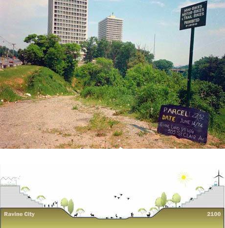 |
| Concept of Ravine City |
**GreenTOpia (2007) - Alana Wilcox, Christina Palassio, Jonny Dovercourt
Subscribe to:
Posts (Atom)